|
FOREST SURVEYS
Having
a forest survey and valuation of a property whether you are looking to sell or
purchase makes sound commercial sense.
Field Data Capture
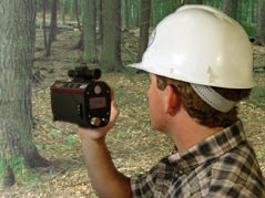
The Woodland Stewardship Company
Ltd, became the first
forest management company in the UK to use laser technology to provide our clients
with more accurate and cost-effective GIS data capture for forest inventories
and mapping. Better data allows
us to make more informed management decisions.
For standing timber inventory valuations we
use
“Procedure 9” from the publication Forestry Commission “Booklet 39 – Forest
Mensuration Handbook.”
Forest
Mapping
Forestry is complex, dynamic, and multidimensional.
Mapping the forest allows us the ability to clearly communicate spatially
and achieve forest management planning goals.
With accurate mapping using hand-held Garmin DGPS in the field and
ArcView GIS we can manage your forest better.
GPS/GIS technology profoundly and positively impacts the way we manage forest
resources. Accurate forest mapping and visualisation helps us to improve
inventory, land administration, sustainable forest planning, timber sales, and
more and therefore understand forest science, economics, and social principles.
This way we will better care for the forest, reach your business objectives, and
complete regulatory reporting requirements.
CONTACT US
|